Tlalnepantla de Baz
Tlalnepantla de Baz (better known as Tlalnepantla) is a city in the state of Mexico.
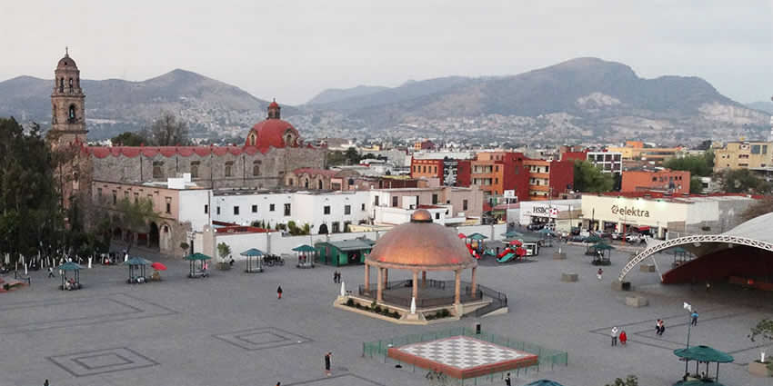
Tlalnepantla, sometimes incorrectly called “Tlanepantla”, is located in the same name municipality in the Valley of Mexico north of Mexico City. Together with Atizapan, it comprises the dense Region XII of the state of Mexico.
Tlalnepantla’s geographical location places it strategically in the Valley of Mexico.
The municipality is surrounded by diverse landscapes, plains, and hills, contributing to a varied and picturesque terrain. This topographical diversity adds to the city’s charm and offers a mix of urban and natural environments.
Climate & Weather
Tlalnepantla experiences a temperate climate typical of the region.
Summers are generally warm with average temperatures, while winters can be cooler, especially during the night. Rainfall is more prevalent in the summer months, contributing to the overall greenery of the area.
The best time to visit Tlalnepantla
The ideal time to visit Tlalnepantla depends on the type of experience one seeks.
The months between November and February constitute the cooler season, making it suitable for those who prefer milder temperatures. The summer months, from June to August, showcase the region’s lush greenery.
Origin of the Name
Tlalnepantla, sometimes incorrectly called “Tlanepantla”. The word “tlalnepantla” comes from the Náhuatl words “tlalli” (“land”) and “nepantla” (“middle”), so the Tlalnepantla name means “the middle land” in Nahuatl.
- The city was known as Tlalnepantla de Galeana, after Hermenegildo Galeana.
- The city was named Tlalnepantla de Comonfort, after Ignacio Comonfort.
- The suffix “de Baz” comes from the last name of Gustavo Baz Prada.
Gustavo Baz Prada was an important politician and soldier of Emiliano Zapata’s army during the Mexican Revolution. After the Revolution, Baz Prada became Governor of the State of Mexico and President of the UNAM).
History & Timeline
Around the 11th century, a people called the Amaquemecan (after whom the municipality of Amecameca is named), migrated to this area following their leader Xolotl to look for a better climate and more food to sustain themselves.
This same Xolotl founded the Tenayuca Oztopolco chiefdom and made the first census ever in the Americas. The Acolhuas, Tepanecas, and Otomis were already established in this land so alliances were made.
The region was conquered and made a tributary of the Aztec Empire.
After the Spanish conquest, the area was evangelized by the Franciscans.
The founding of modern Tlalnepantla was the result of a dispute between the towns of Tenayuca and Teocalhueyacan as to which should be the site of the Franciscan monastery and religious center for the area.
After discussions, the final result was the founding of a monastery midway between these two cities (Tenayuca and Teocalhueyacan), hence the name Middle Land. This Corpus Christi monastery was built in 1550.
In 1825, Tlalnepantla was recognized as a district of the State of Mexico.
Tlalnepantla was declared a city in 1948.
Tourist attractions in Tlalnepantla and surrounding areas
The church and monastery of Corpus Christi were built by both Mexicas and Otomis of pink and gray stone. The side gate shows clearly the influence of both of these people. In 1963, the church gained cathedral status.
- The aqueduct Tlalnepantla – Villa de Guadalupe (built in Colonial times)
- The Caja del Agua also dates from the colonial period
- The Hacienda of Santa Mónica
- The Hacienda de Emmedio
- The Centro Cultural Sor Juana Inés de la Cruz
Prehispanic legacy
Two notable pyramids lie in the municipality’s limits.
Tenayuca Pyramid
The pyramid at Tenayuca is a small version of the Templo Mayor in Tenochtitlan. It has dual staircases, each leading to two temples, at the top of the pyramid. One was dedicated to Tlaloc and the other one to Huizilopochtli.
Serpent sculptures surrounding the pyramid are possibly of pre-Aztec origin.
There is a small museum of the site and the history that surrounds it.
Santa Cecilia Acatitlan
Another smaller pyramid is at Santa Cecilia Acatitlan, just north of Tenayuca. This one was rebuilt as the original was destroyed and some of its blocks were used to build the Santa Cecelia Parish church that is next to it.
This pyramid has one staircase and one temple atop.
There is a museum with a small collection of pre-Hispanic sculptures.
How to get there to Tlalnepantla
Getting to Tlalnepantla is easy due to its proximity to Mexico City.
The following are common transportation options:
Mexico City has Terminal de Autobuses de Pasajeros de Oriente (TAPO) and Terminal de Autobuses de Pasajeros de la Ciudad de Mexico (Tapo). From these terminals, you can find buses that connect to Tlalnepantla.
Mexico City’s Line 4 metro (subway) connects Tlalnepantla with the city.
Taxis and rideshare services are available in Mexico City and can take you directly to Tlalnepantla. Make sure to use authorized services, and it’s often helpful to have the destination address written down.
Renting a car is another option if you prefer the flexibility of driving.
Before your journey, it’s advisable to check the latest travel information and routes. Tlalnepantla’s central location and connectivity make it accessible for visitors arriving from various parts of Mexico City and beyond.
Let us know if this article was useful for you