Where is the most active hurricane regions in Mexico?
In Mexico, hurricanes occur on average about 25 times a year.
Mexico is susceptible to hurricanes, primarily affecting regions along its coasts. Hurricanes occur in the Caribbean and Pacific coastal regions. With less risk of destruction, hurricanes also occur in the Gulf of Mexico.
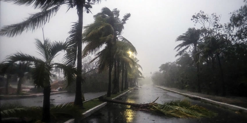
Hurricane formation is influenced by high sea surface temperatures, exceeding 26 C, providing the necessary heat for storms to form. Hurricanes bring strong winds, intense rainfall, and changes in air temperature.
Lightning also can occur during storms, but it’s not a primary concern compared to other hazards like wind and rainfall. However, it’s always advisable to exercise caution and avoid open areas during thunderstorms.
Specific hurricane impacts can vary based on the storm’s intensity, trajectory, and local topography. Staying informed through meteorological updates and following local authorities’ guidelines is crucial for safety.
The hurricane season usually lasts from early June to late November.
Hurricane season conditions
Conditions during the hurricane season may vary depending on time and region.
Early Season (June-July): Early in the hurricane season, typically June and July, activity may be more moderate, but tropical cyclone formation is possible. Winds and rain may be less intense but remain vigilant.
Peak Season (August-September): The frenetic activity of hurricanes usually peaks in August and September. During this period, major hurricanes with strong winds and intense rain are more likely to occur here.
Late season (October-November): Towards the end of the season, in October and at sunset, hurricane activity usually gradually decreases, but tropical storms and hurricanes may still be present with less activity.
Specific conditions may be considered each year and not all effects may be negative. Hurricane season is a period of increased risk, and travelers are advised to monitor forecasts, especially during the peak season.
Hurricane-prone regions in Mexico
While Mexico is known as a paradise for beachgoers, it’s important to note that certain regions within the country are prone to hurricanes. These areas face a higher risk of hurricanes due to their geographic location.
The Caribbean Coast, the Gulf of Mexico, the Pacific Coast, and the Baja California Peninsula, are known for their high risk of hurricanes. These regions frequently experience hurricanes between June and November.
Hurricanes in the Mexican Caribbean
The Caribbean Sea acts as a breeding ground for hurricanes due to warm waters and favorable atmospheric conditions. Mexico’s Pacific coast, especially the eastern side, is also prone to these powerful storms.
Hurricanes pose significant dangers, bringing strong winds, heavy rainfall, and storm surges that can lead to flooding and landslides.
- Hurricanes can bring extremely high wind speeds, often exceeding 119 km/h.
- Intense rainfall is a hallmark, leading to potential flooding.
- Rainfall amounts can be substantial over a short period.
- Temperatures may drop during the storm due to cloud cover and rain.
Hurricane Wilma in 2005 was one of the most intense hurricanes ever recorded in the Atlantic basin. It made landfall on the Yucatán Peninsula and later struck the Gulf Coast, including areas like Cozumel and Cancún.
Hurricane Dean in 2007 made landfall on the Caribbean coast of the Yucatán Peninsula, affecting areas like Chetumal, before moving into the Gulf of Mexico. It caused widespread damage and prompted evacuations.
Hurricanes in the Gulf of Mexico
The Mexican Gulf Coast, including states like Veracruz and Tamaulipas, can also experience hurricane impacts. Specific locations can vary in their vulnerability. The hurricane season runs here from June to November.
Veracruz faces a particularly elevated risk during this period. Its warm waters and geographical location make it a focal point for hurricane formation. Numerous coastal communities remain vigilant and prepared.
Tamaulipas, another Gulf state, shares this vulnerability.
Although the frequency and intensity of hurricanes can vary, the importance of readiness cannot be overstated. The region’s coastal areas must be prepared to face the challenges posed by these natural phenomena.
Hurricanes on the Pacific coast of Mexico
There is also a threat of hurricanes along Mexico’s Pacific coast.
The eastern Pacific Ocean may be prone to hurricane formation due to warm water temperatures and favorable atmospheric conditions. These storms can bring strong winds, intense rain, and flooding.
The Pacific hurricane season typically runs from May to November, with peak activity during the summer and early autumn months. Residents should be prepared and monitor weather information for their safety.
- Hurricanes can generate powerful winds, causing significant damage.
- Heavy rainfall is common, contributing to the risk of floods and landslides.
- Similar to the Atlantic side, there may be fluctuations in temperature.
Hurricane Patricia in 2015 became the strongest hurricane ever recorded in the Western Hemisphere. While it mainly impacted the Pacific coast region of Mexico, it caused significant rainfall, flooding, and landslides.
On October 25, 2023, Hurricane Otis struck Acapulco, reaching the status of a category 5 hurricane. The hurricane caused severe damage to Acapulco’s infrastructure, causing electricity, water, and gasoline outages.
Hurricanes in the Baja California Peninsula
- Hurricanes can bring strong winds.
- While not as prone to heavy rainfall as some other regions.
- There’s still a risk of flooding during storms.
- Changes in temperature are possible during a hurricane.
Avoid traveling to these areas during the hurricane season to ensure a more enjoyable vacation experience. Check weather forecasts and hurricane updates before planning visits to these regions during the hurricane season.
Hurricane Odile in 2014 struck the Baja California Peninsula, impacting areas such as Cabo San Lucas and San Jose del Cabo. The hurricane caused extensive damage in the area with strong winds and heavy rainfall.
Resorts and cities prone to hurricanes
Hurricanes often do not make landfall in Mexico, but turn northward beforehand. The remnants then cause gusts of wind and rain on land. The most affected regions are the Yucatan Peninsula, West, and Southwest.
Certain resorts and cities in Mexico are susceptible to hurricanes, primarily along the coastal regions of the Gulf of Mexico and the Pacific Ocean. The hurricane season in Mexico typically peaks from June to November.
Atlantic Coast hurricane areas:
- Cancún
- Riviera Maya
- Cozumel
- Chetumal
Mexican Gulf hurricane areas:
- Veracruz
- Tampico
- Tuxpan
- Reynosa
- Ciudad Madero
- Altamira
Pacific Coast hurricane areas:
- Mazatlan
- Puerto Vallarta
- Manzanillo
- Lazaro Cardenas
- Acapulco
Baja California hurricane areas:
- Cabo San Lucas (Los Cabos)
- San Jose del Cabo (Los Cabos)
Before making travel plans, check the forecast and current weather conditions.
National Meteorological Service
The National Meteorological Service (Servicio Meteorológico Nacional or SMN) in Mexico is the government agency responsible for monitoring and issuing alerts related to weather conditions, including hurricanes.
The SMN operates under the National Water Commission (CONAGUA).
The SMN provides the public with weather forecasts, warnings, and updates on hurricanes and tropical storms. It is the primary source for monitoring and disseminating information about weather-related events in Mexico.
To stay informed about hurricanes and receive official alerts, you can check the updates from the National Meteorological Service through their official channels, including their website and other social media platforms.
Additionally, local civil protection authorities may also provide information and instructions during hurricane events.
If you’re traveling to Mexico during hurricane season
When traveling to Mexico during the hurricane season, it’s important to be prepared for potential weather-related challenges. Here’s a list of what to bring with you to Mexico during the rainy and hurricane season:
- A waterproof jacket or poncho
- Water-resistant or quick-drying footwear
- Compact umbrella for light rain
- Waterproof or water-resistant backpack
- Waterproof cases or bags for electronic devices
- Install weather apps for real-time information
- Save local emergency numbers and contacts
Regularly check weather forecasts and local advisories during your stay.
Most violent hurricanes in Mexico since 2020
Otis: October 17 to October 25, 2023
- Otis: October 17-25, 2023
- Wind speed: max. 269 km/h
- Diameter: max. 556 km
- Air pressure: below 923 mbar
- Saffir-Simpson scale: category 5
- Affected regions: Southwest and West
Lidia: September 30 to October 11, 2023
- Wind speed: max. 222 km/h
- Diameter: max. 556 km
- Air pressure: below 942 mbar
- Saffir-Simpson scale: category 4
- Affected regions: West and Central-North
Idalia: August 24 to September 2, 2023
- Region: Gulf of Mexico
- Wind speed: max. 194 km/h, on land: max. 115 km/h
- Diameter: max. 1000 km
- Air pressure: below 944 mbar
- Saffir-Simpson scale: category 3
- Affected regions: Yucatan Peninsula
Hilary: August 13-21, 2023
- Wind speed: max. 232 km/h, on land: max. 213 km/h
- Diameter: max. 1333 km
- Air pressure: below 939 mbar
- Saffir-Simpson scale: category 4
- Affected regions: Southwest and Baja California
Roslyn: October 20-24, 2022
- Wind speed: max. 213 km/h
- Diameter: max. 259 km
- Air pressure: below 954 mbar
- Saffir-Simpson scale: category 4
- Affected regions: West, North, Central-North and Northeast
Roslyn: October 17-24, 2022
- Wind speed: max. 213 km/h, on land: max. 194 km/h
- Diameter: max. 370 km
- Eye: max. 37 km
- Air pressure: below 954 mbar
- Saffir-Simpson scale: category 4
- Affected regions: Southwest, West, North, Central-North and Northeast
Orlene: September 28 to October 3, 2022
- Wind speed: max. 213 km/h, on land: max. 198 km/h
- Diameter: max. 252 km
- Air pressure: below 954 mbar
- Saffir-Simpson scale: category 4
- Affected regions: West and North
Orlene: September 26 to October 4, 2022
- Wind speed: max. 213 km/h, on land: max. 148 km/h
- Diameter: max. 370 km
- Air pressure: below 949 mbar
- Saffir-Simpson scale: category 4
- Affected regions: North
Ian: September 22 to October 1, 2022
- Wind speed: max. 259 km/h
- Diameter: max. 845 km
- Air pressure: below 937 mbar
- Saffir-Simpson scale: category 5
- Region: Gulf of Mexico
Ian: September 19 to October 2, 2022
- Wind speed: max. 250 km/h
- Diameter: max. 1482 km
- Eye: max. 93 km
- Air pressure: below 937 mbar
- Saffir-Simpson scale: category 4
- Region: Gulf of Mexico
Marty: August 23-27, 2021
- Wind speed: max. 74 km/h, on land: max. 69 km/h
- Diameter: max. 741 km
- Air pressure: below 1002 mbar
- Saffir-Simpson scale: tropical storm
- Affected regions: Baja California
Kevin: August 6-15, 2021
- Wind speed: max. 102 km/h
- Diameter: max. 1222 km
- Air pressure: below 994 mbar
- Saffir-Simpson scale: tropical storm
- Affected regions: West and Baja California
Iota: November 12-18, 2020
- Region: Caribbean Sea
- Wind speed: max. 250 km/h, on land: max. 120 km/h
- Diameter: max. 1000 km
- Air pressure: below 917 mbar
- Saffir-Simpson scale: category 4
- Affected regions: Yucatan Peninsula and Southwest
Eta: October 31 to November 14, 2020
- Region: Gulf of Mexico
- Wind speed: max. 241 km/h, on land: max. 93 km/h
- Diameter: max. 815 km
- Air pressure: below 922 mbar
- Saffir-Simpson scale: category 4
- Affected regions: Yucatan Peninsula and Southwest
Delta: October 4-11, 2020
- Region: Gulf of Mexico
- Wind speed: max. 222 km/h, on land: max. 176 km/h
- Diameter: max. 852 km
- Air pressure: below 953 mbar
- Saffir-Simpson scale: category 4
- Affected regions: Yucatan Peninsula
Lowell: September 20-27, 2020
- Wind speed: max. 83 km/h, on land: max. 46 km/h
- Diameter: max. 1111 km
- Air pressure: below 1001 mbar
- Saffir-Simpson scale: tropical storm
- Affected regions: West
Beta: September 17-25, 2020
- Region: Gulf of Mexico
- Wind speed: max. 102 km/h, on land: max. 87 km/h
- Diameter: max. 741 km
- Air pressure: below 993 mbar
- Saffir-Simpson scale: tropical storm
- Affected regions East, Northeast, and Yucatan Peninsula
Laura: August 20-29, 2020
- Region: Gulf of Mexico
- Wind speed: max. 241 km/h, on land: max. 124 km/h
- Diameter: max. 741 km
- Air pressure: below 937 mbar
- Saffir-Simpson scale: category 4
- Affected regions: Yucatan Peninsula
Genevieve: August 16-22, 2020
- Wind speed: max. 213 km/h, on land: max. 167 km/h
- Diameter: max. 556 km
- Eye: max. 93 km
- Air pressure: below 950 mbar
- Saffir-Simpson scale: category 4
- Affected regions: Baja California
Cristobal: June 1-12, 2020
- Region: Gulf of Mexico
- Wind speed: max. 93 km/h
- Diameter: max. 815 km
- Air pressure: below 982 mbar
- Saffir-Simpson scale: tropical storm
- Affected regions: Yucatan Peninsula
Amanda: May 30-31, 2020
- Wind speed: max. 65 km/h
- Diameter: max. 1111 km
- Air pressure: below 1003 mbar
- Saffir-Simpson scale: tropical storm
- Affected regions: Southwest
These evaluations are based on data from the National Centers for Environmental Information of the National Oceanic and Atmospheric Administration (NOAA). Individual data have been summarized or translated.
Source: worlddata.info
Let us know if this article was useful for you